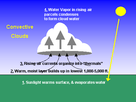
Clouds are possibly the most interesting (and beautiful) of all weather phenomena. While
there are a wide variety of cloud shapes and sizes, they are all made of the same thing: condensed water or ice.
The air in the cloud has been cooled (almost always because it is rising) and it can no longer hold all of
the water vapor it contains. Some of that (invisible) water vapor condenses
to form (visible) cloud droplets or ice crystals.
The cloud example pictured above is considered "convective", because it is produced from warm air pockets rising
("convecting") from the underlying surface. Convective clouds are typically smaller, a hundred yards to a few
miles across. "Stratiform" clouds, however, typically cover much larger areas
and are caused by much broader layers of more slowly rising air. Stratiform clouds have a more uniform, featureless
appearance, and often cover the whole sky. Some different types of clouds can be seen here.
|